Happy 10/02 Day!
In the global conflict for dominance over the shape of the earth’s surface, plate tectonics has been the clear victor over erosional processes in the 1002 Area of the Arctic National Wildlife Refuge — something I think we should all be happy about and celebrate for a variety of reasons this October 2nd (10/02).
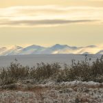
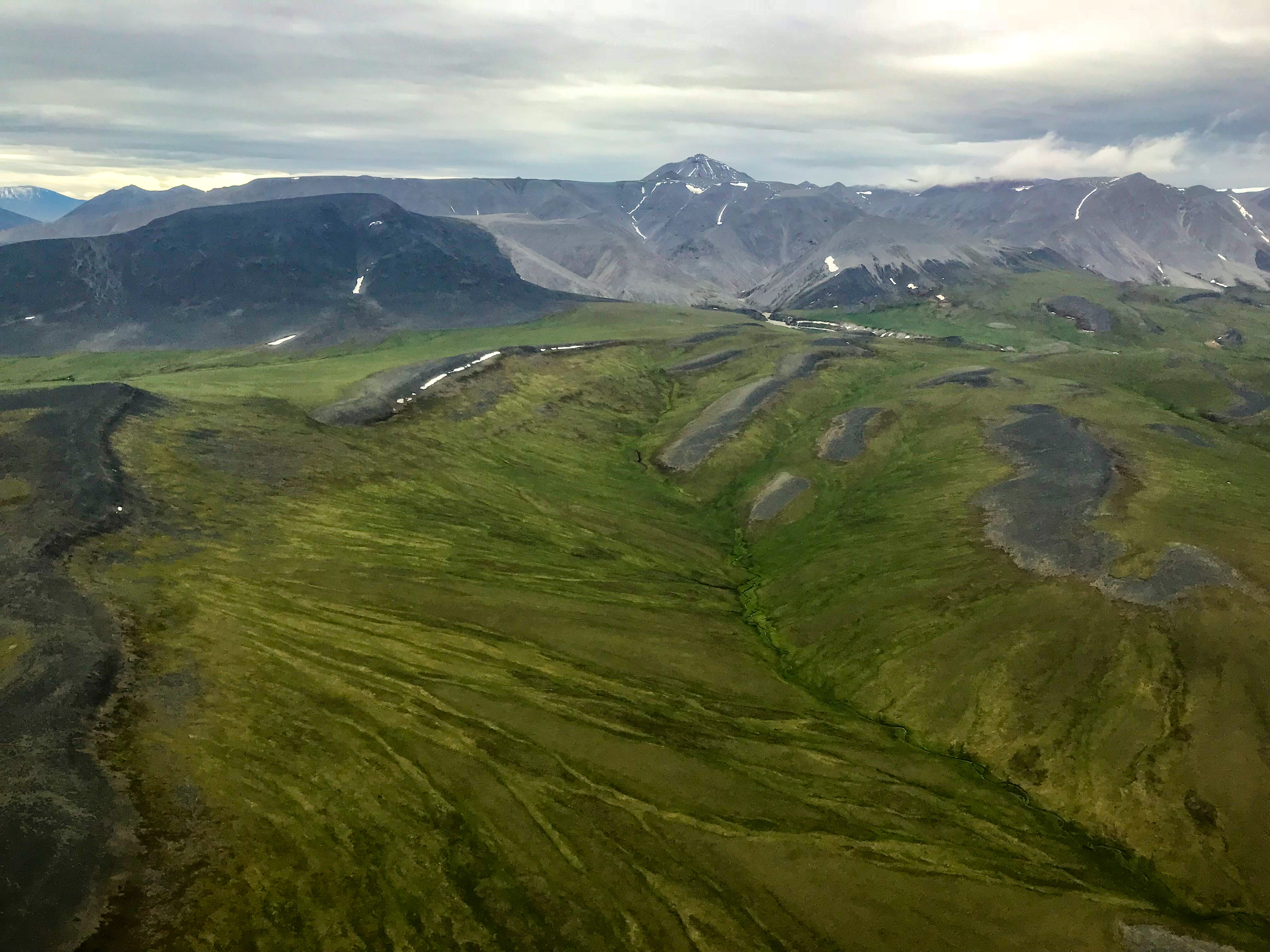
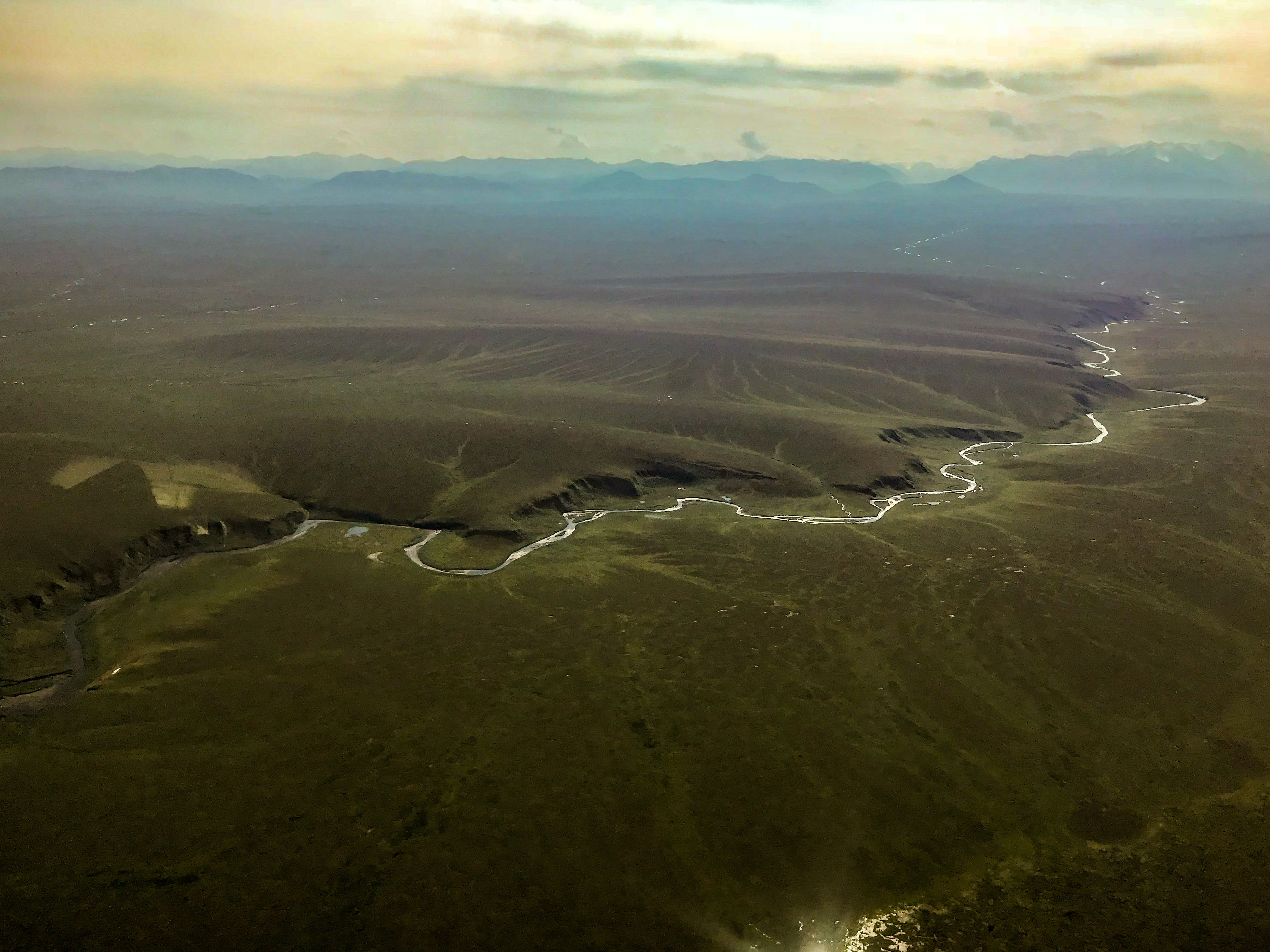
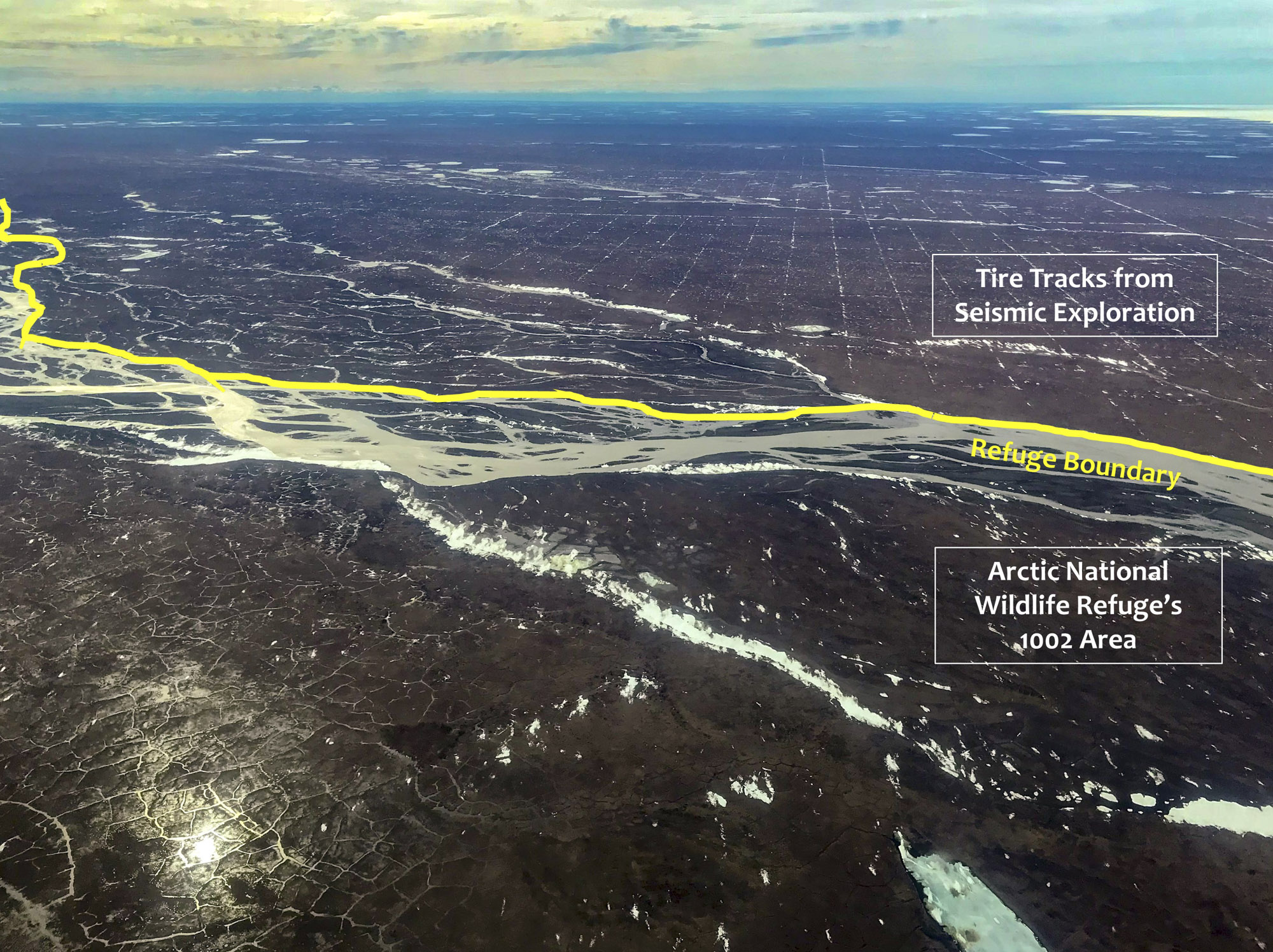
Here the Brooks Range swings far to the North, with its front range only 20 miles from the relatively immovable bed of the Arctic Ocean, creating a rumpled landscape within the 1002 Area, folded and faulted by millions of earthquakes, such as the M6.3 about 2 months ago. Hardly a coastal ‘plain’, here the rivers draining these mountains flow through the ravines and gullies that so characterize the 1002 Area that they create the densest concentration of polar bear dens in Alaska, as the blowing snow creates drifts meters deep in these ravines into which these bears create condos to birth and protect their cubs during the cold winter months. The caribou enjoy this tectonic victory as well—within an easy day’s walk they can enjoy the east-west winds along the coast or the north-south winds within the mountains, whichever keeps them and their newborn calves out of the insect swarms most efficiently. The unloved mosquito also thrives here – while there are no large lakes here because the terrain is too steep, there are hundreds of perched tussock wetlands with millions of small pockets of water to help their young to multiply. Along no lengthier stretch of our Arctic coastline has erosion lost this battle so spectacularly, thus we cannot fully understand the ecology here without also understanding the geology. But we cannot fully understand the geology without conducting 3D seismic investigations of the subsurface to unravel the history of this warped and buckled landscape.
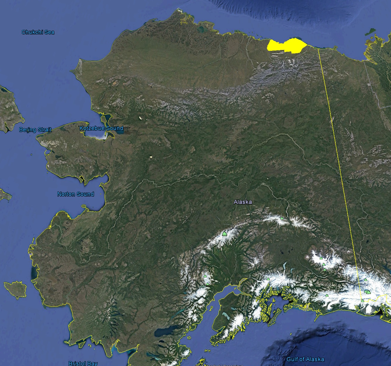
The 1002 Area, in yellow, is unlike the rest of our Arctic Ocean coastal zone. Here the Brooks Range is actively trying to reach the coast and is already within 20 miles of it, creating the steepest watersheds draining into the Arctic Ocean. Hardly a coastal ‘plain’, zoom into Google Earth and you will see that there are almost no lakes here, because the region is not flat like the coastal plains to the west.
Here in the 1002 Area, the mountains nearly reach the coast, creating the steepest watersheds in Arctic Alaska. Does this looks like a plain to you?
Mountain building is still ongoing within the 1002 Area. The M6.3 earthquake last August was not far from this location.
In the 1002 Area, the folded geologic layers tell the rivers where to go.
Steep bluffs like these are great for creating snow drifts many meters deep. Polar bears from around the Arctic preferentially come here to create their dens because of the 1002 Area’s unique geological history.
The good news is that 3D seismic is now allowed in this protected area thanks to a Congressional Act last December, the bad news is that the current methods are simply not suitable to protect this unique landscape and its ecology from the same damage that has permanently scarred the adjacent, unprotected tundra that overlies the enormous oil fields to the west. The methods of 40-60 years ago were particularly destructive despite being the best methods for the time – bulldozers pushed aside the tundra in long straight lines, and this exposure of the ice beneath the tundra has caused these trails to enlarge over time as the subsurface ice melts, turning them into a series of lakes connected by rivers that will not disappear in our lifetimes. Destructive potential was reduced substantially once it was restricted to winter time only – the frozen ground and the snow cover above it greatly reduced the damage caused by the dozens of large, heavy vehicles driving over it. But they did not eliminate the damage completely. And here, in the 1002 Area, a place that I consider my backyard, where I’ve spent the past 15 years studying the impacts of climate change on the landscape, where I’ve raised my son, where I have tons of memories, here, despite my interest in understanding the subsurface geology, here I consider any seismic methods that leave any trace, create any impact, unacceptable. We can do better. So here, I’m asking for the help of those who love the 1002 Area for any reason, whether for its pristine landscape, unique ecology, untold subsurface riches, or reasons known or unknown to you, here I ask for your help in holding the impacts of this seismic research to a higher standard, to demonstrate to the world that we can conserve and develop resources responsibly, and to understand that part of acting responsibly is to act respectfully towards those that don’t share your opinion, to find the common ground that all can live with. Impact-free seismic is in everyone’s best interests, and striving for that is perhaps the worthiest goal that all involved can aim for.
Here you can see a seismic trail from probably the 1960s running into the distance. Best practice at the time was apparently to scrape off the tundra with a bulldozer. In any case, this trail will not disappear in our life time, as the change in surface energy balance caused by the disturbance has begun to melt the frozen soil underneath, creating lakes and rivers which will only continue to enlarge themselves in the current climate. Also seen here is what seems to be a well drill pad with massive thermokarst from related disturbances to the tundra. Exacerbating any future development efforts is the fact that the tundra and subsurface are much warmer now than they were 40 years ago when Prudhoe Bay and pipeline construction were at their peak, so any new developments cannot depend on old methods to work as well as they once did.
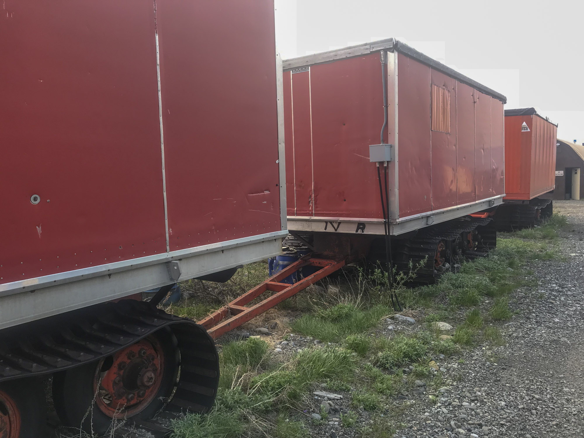
Here’s an example of the type of vehicles that used to be dragged around the tundra to support such work. Pay particular attention to the metal cleats bolted onto the tracks — those aggressive treads were designed for maximum traction.
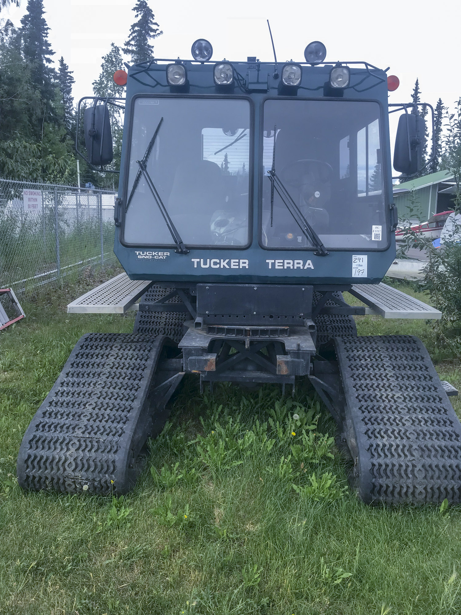
Unlike the old-style treads with metal cleats, these modern vehicles are designed not only to spread their load at a very low pressure but these treads cannot grab into the tundra as viciously as the old-style, a tremendous improvement. But it doesn’t matter if the tire pressure here is only 2-3 psi, all that matters is whether that pressure is less than the damage-free bearing strength of Arctic tundra, which still seems to be an open question due to lack of research, seemingly caused by a system that has little motivation to find out on its own.
Despite the large, wide tracks of these vehicles, their low surface pressure is simply not enough to avoid compacting the snow and crushing the tundra beneath it, especially when tracks are reused or when vehicles get stuck. Though the fibrous tundra mat is usually not breached, it is compressed and causes the ground to be slightly soggier here, which alters the surface energy balance and evolutionary botanical pathways regardless of whether the mat rebounds to its original height. Thus whether due to the broken stems or the new growth that greens up more quickly in this soggier ground, these trails do not disappear once the snow melts. The process is not well understood because there has never been a systematic scientific study of it but, regardless of the cause, the impact of trails created by modern 3D seismic methods do not disappear once the snow melts and worse, due to the geological differences between the 1002 Area and elsewhere, the 3D seismic work proposed here this winter also has the potential for substantial ecological harm.
The original proposal to conduct 3D seismic in the 1002 Area this winter was only 12 pages long (plus some boilerplate appendices) and it’s authors gave no indication that they understand that the landscape here is different than the comparatively flat oil fields to the west or that there is anything unique or special to these protected lands to the American people – basically it just says ‘we want to drag a four star hotel for 300 people on a 200 m x 200 m grid across the entire 6000 km2 of the 1002 Area and we will use best practices to try to prevent causing any damage’. Perhaps this is understandable given that they likely have used nearly this exact same proposal numerous times before, because it essentially just regurgitates the permit stipulations from prior work such as this one approving their work just across the Refuge boundary at Pt Thomson (the same location I studied this summer). The BLM then apparently rewrote this proposal and added new information on their own, presumably in response to criticisms citing the lack of such information, and though it is an improvement it is still only 7 pages long, quite brief for such an enormous undertaking in such a pristine, fragile landscape (to me it also begs the question, why is the permitting agency rewriting an industry proposal by making it more complete and adding new information?, but I digress…). While the new proposal does mention the terrain differences, it still fails to give any suggestion that the American people care about this landscape more than they care about the unprotected oil fields to the west. It says there will be a native observer in the field at all time to protect subsistence use rights, but how about a team of impartial scientists to protect the landscape itself? While I think it’s great to have a native observer protecting the rights of the handful of Kaktovik residents who actually go fishing in the Hulahula River in winter, how about the rights and sensibilities of the 200 million Americans that oppose drilling activities out here in fear of losing their wilderness and the rights that their ecology has enjoyed to exist without human impacts? Just because exploration is approved by law here does not mean unsupervised destruction and desecration is approved by law. And it is the lack of such awareness to the sensitivity of this issue that bothers me the most of the SAExploration proposal, as any method can cause permanent impacts in this fragile landscape in the hands of arrogant or insensitive users.
A grid pattern of this density over this large an area works out to about 38,000 miles of travel for a single vehicle (consider 1 square kilometer will have a 5 x5 grid of lines that are each 1 km long, so 10 linear kilometers of driving for each 1 km2, or 61,000 km (37,900 miles) of grid lines). To get a better sense of what this grid would look like, I created this KML file for Google Earth. Given that the proposal lists over a dozen vehicles dragging hundreds of tons of men, buildings, and supplies on sleds, this could amount to over half a million miles of travel over this fragile terrain! But driving 24/7 in the dead of the dark Arctic winter, what could go wrong? According the seismic proposal, nothing. According the the US Fish and Wildlife Service who reviewed and rejected this proposal, about 20 pages of worth of things could go wrong. But this proposal has long legs – apparently as a result of this rejection, the powers that be in Washington appointed the BLM in charge of the permitting process, nominally because they have more experience with the NEPA process, but (coincidentally?) unlike the USFWS they found ‘no significant impacts’ were likely with this work such that the NEPA process was not really needed here, such that no EIS or a public comment period is required. So unless challenged legally, this work could begin in a few months without any public comment or further environmental review, and if you look at the dates on the Pt Thomson seismic approval letter, it’s only days before work actually began there, such that there is still time to fight and lose such a legal battle…
Here’s really the question: Do you want to see this checkerboard covering the entire 1002 Area? Even if it only lasted a year? This photo of mine of the 2018 Pt Thomson 3D seismic impacts made it into a New York Times article this summer. Those trails were still visible within the tundra in September, three months later, long after the snow melted.
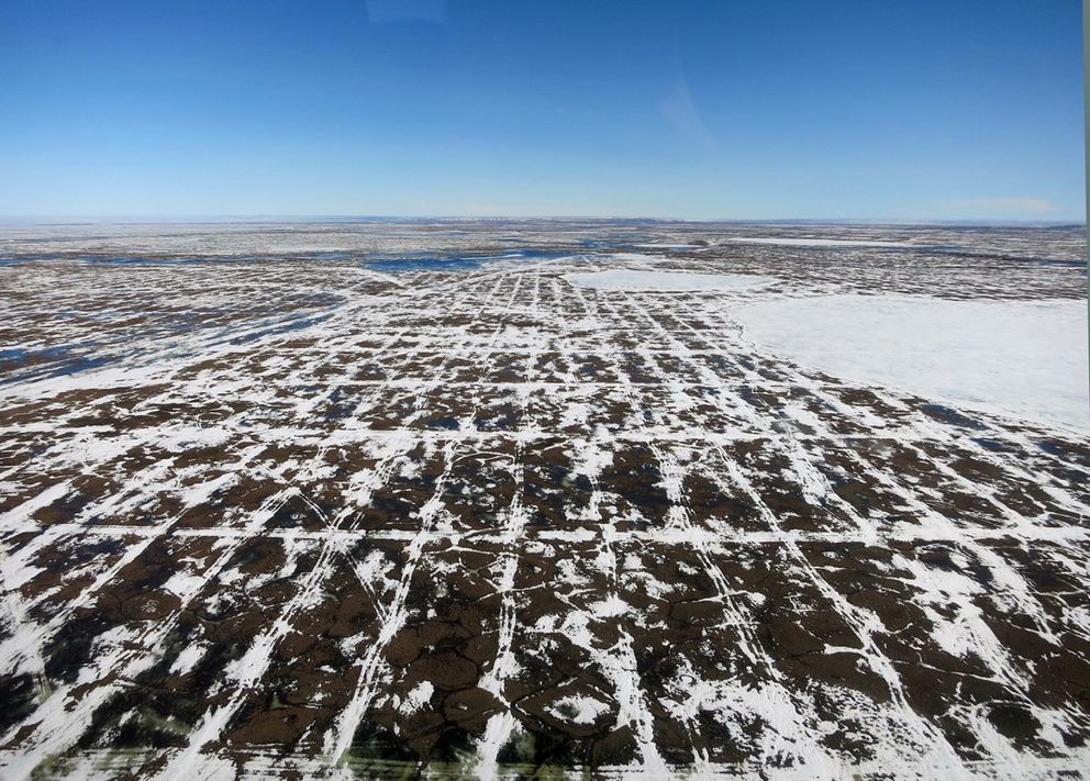
Here are the tracks left behind from seismic work much further to the west. This photo comes from this article in the Anchorage Daily News.
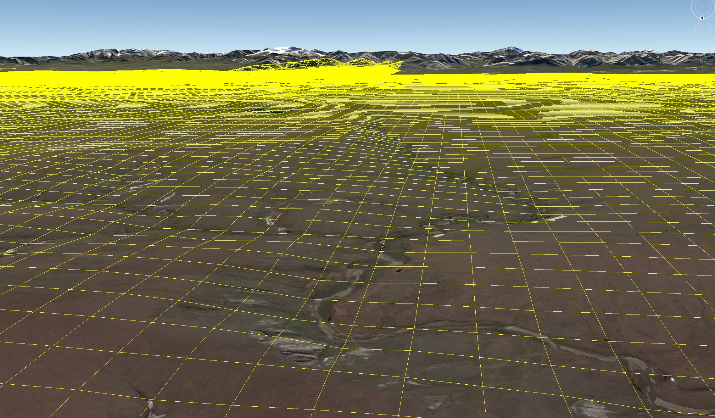
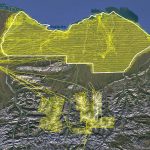
Here’s what a 200 meter by 200 meter grid looks like superimposed over the 1002 Area landscape within Google Earth. It crudely matches the perspective in the photo I took below. Again the question to me is: Is saving a few bucks to skip the research needed to improve seismic methods worth the risk of this checkerboard being forever visible or impacting the fragile ecology here? You can download this KMZ file I created for Google Earth here to help you decide.
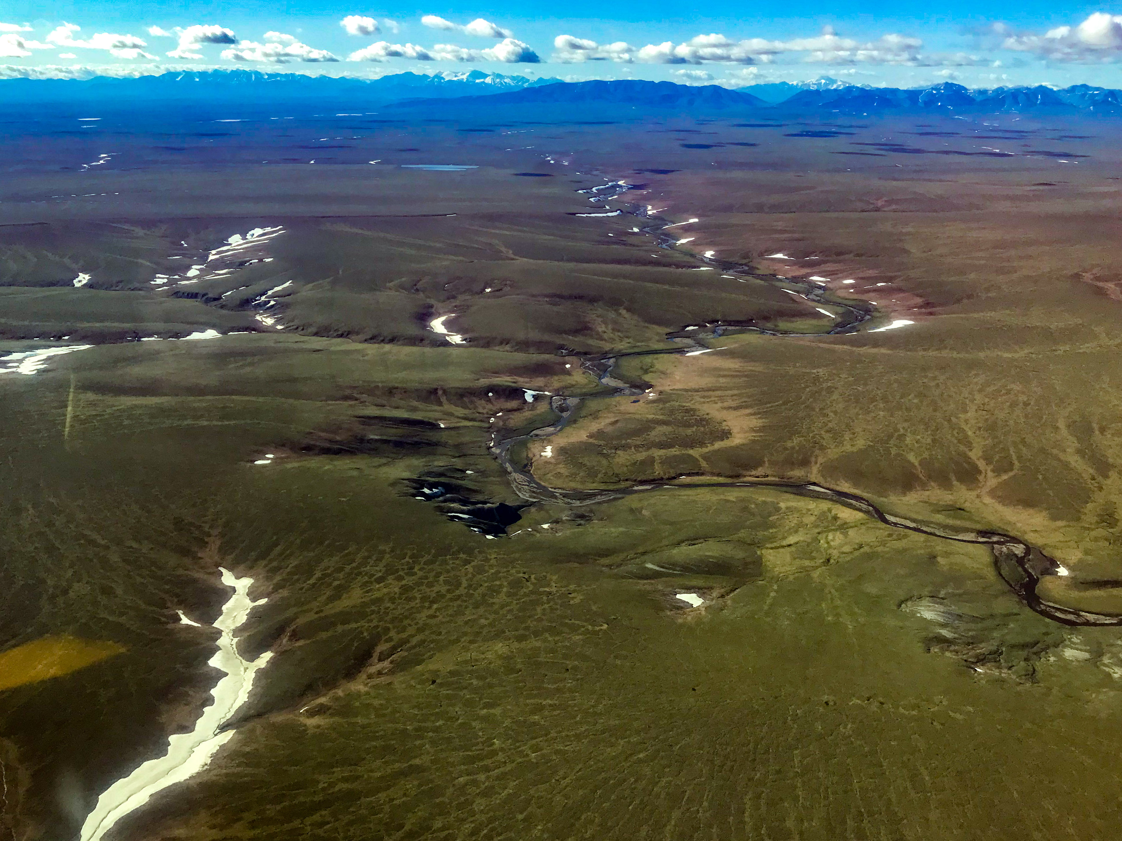
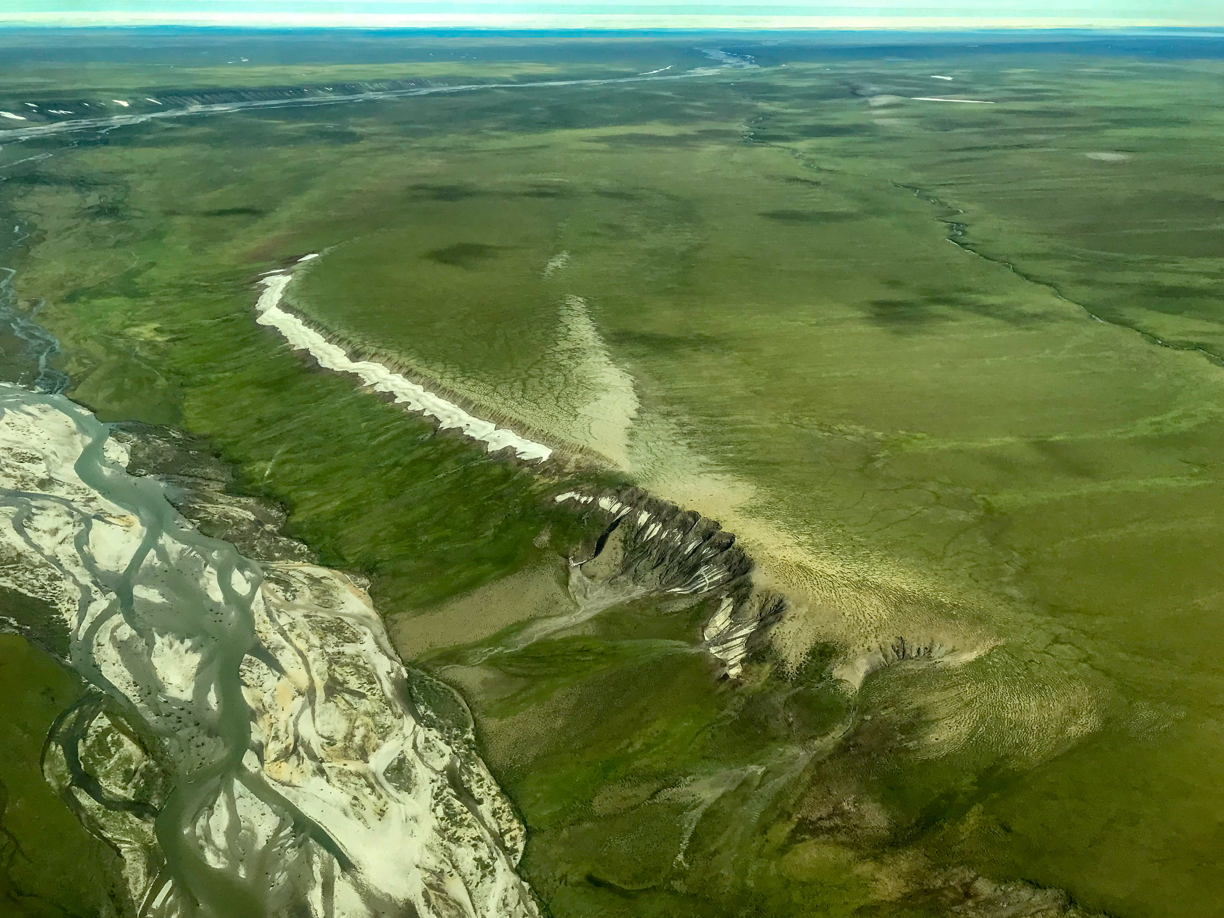
This photograph is roughly the same perspective as the previous graphic from Google Earth. The complex topography here at the coast is caused by the same forces that are building the mountains only a few miles away to the south. That is, the rivers here would like to turn this into a coastal plain, but the ground is moving up faster than the rivers can wear it down.
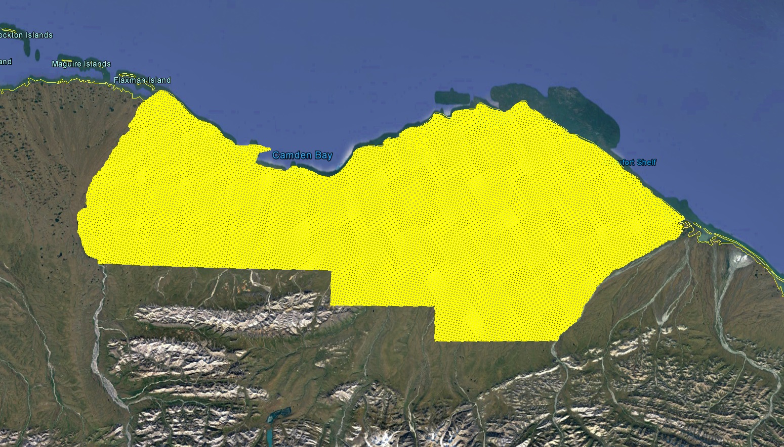 Here the 200 meter x 200 meter grid is so dense that it forms a solid block of yellow when viewed all at once. That’s 38,000 miles of trail creating about 150,000 acres of impact in the short term — if even 1.3% of that area (2,000 acres) creates a permanent impact, that would use up the entire 2,000 acres permitted by law for the entire drilling operations! That is, it is the in the best interests of even the staunchest of pro-development interests to improve the 3D seismic methods proposed to be used here else it will take another Act of Congress to increase the 1200 acre impact allotment, and that’s simply never going to happen with a checkerboard permanently etched into the tundra of a place that the vast majority of American citizens consider sacred. We can do better.
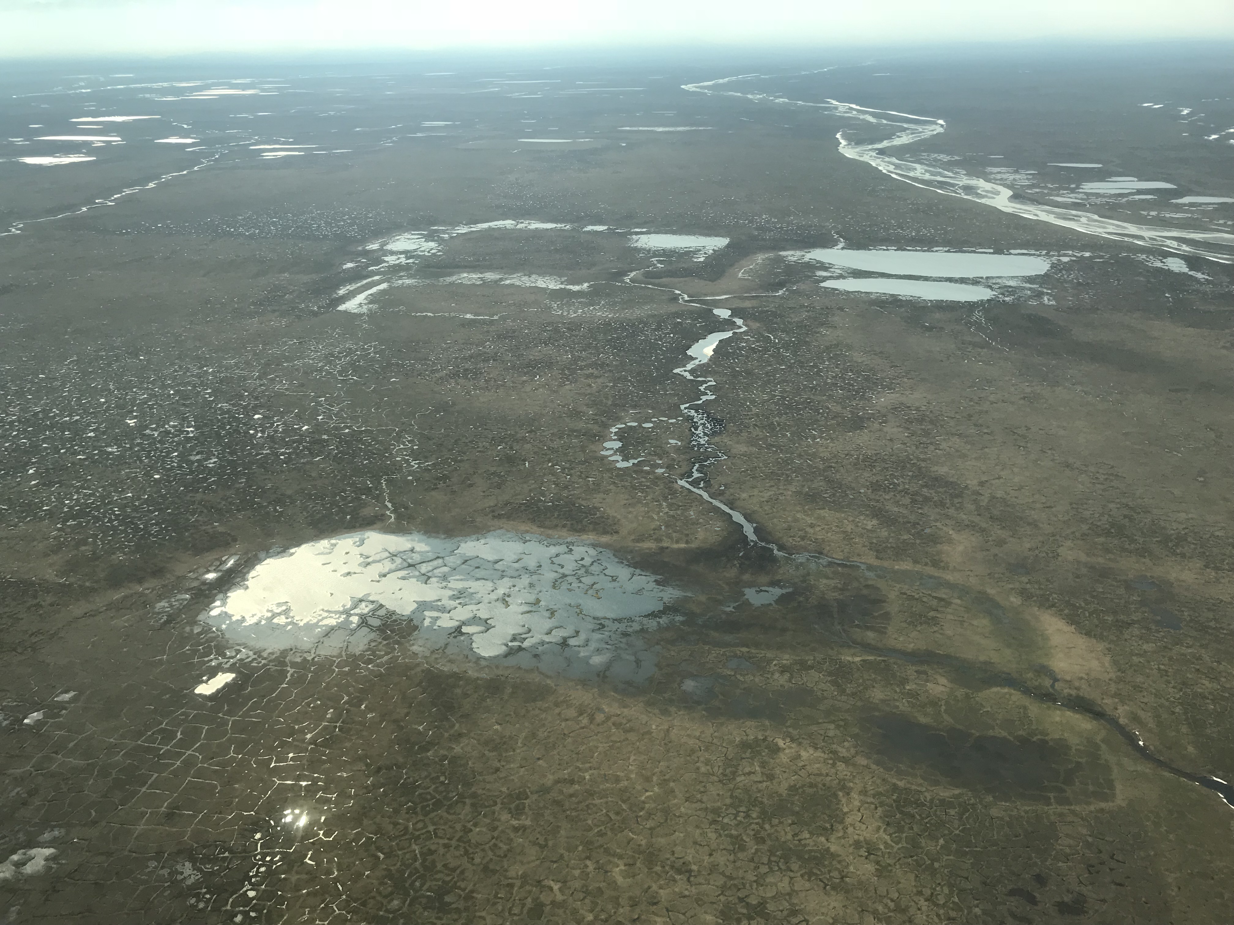
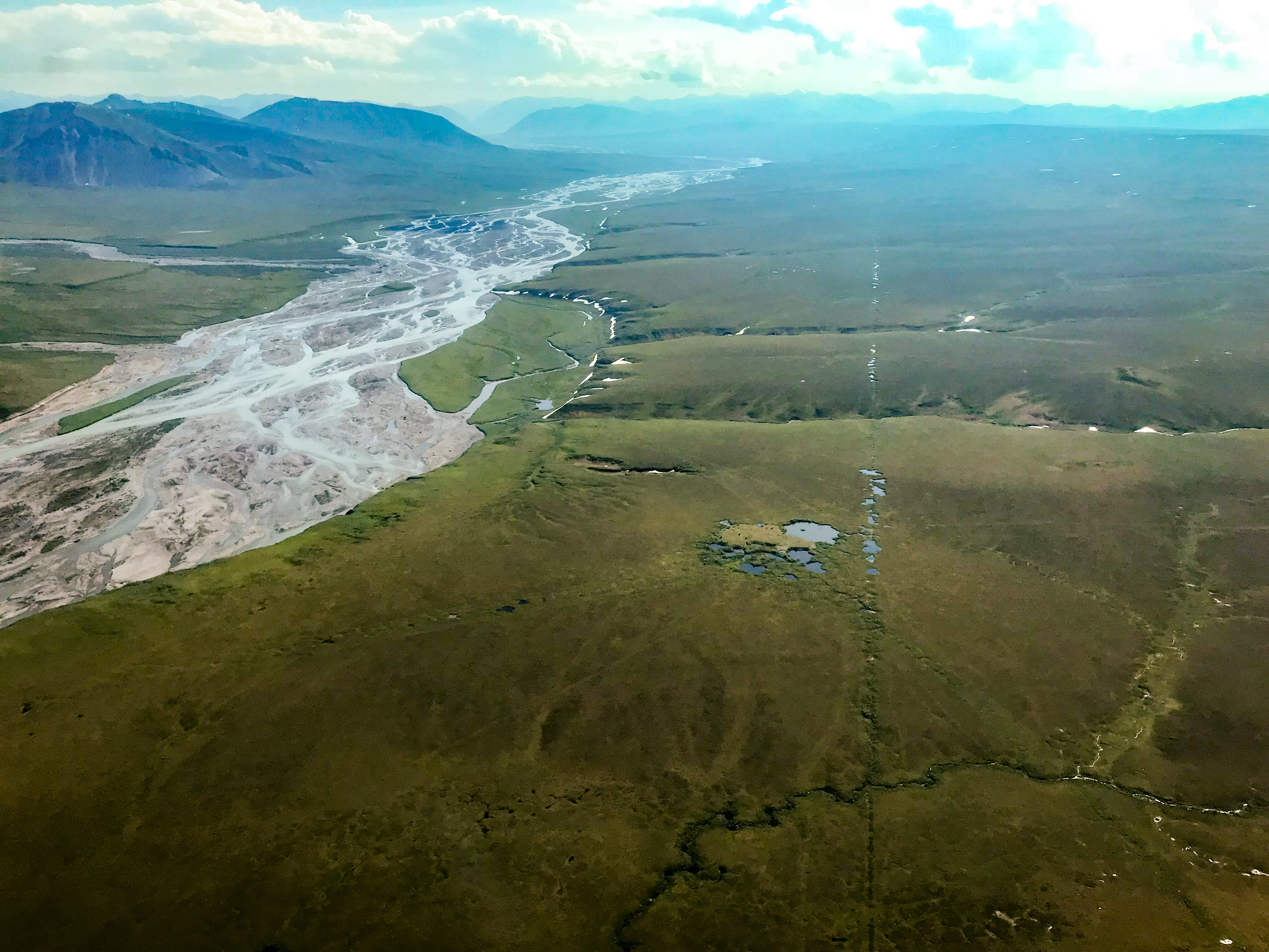
The 1002 Area is a hydrologically active region because it is so steep. Here is one of the few locations where large lakes exist, or existed, surrounded by perched wetlands which you can see glinting in the sun. You can see the size of these lakes has changed over time, with drainage events likely taking only a day or two once begun, yet they are still surrounded by standing water. Imagine the changes that a 200 m grid of 6 inch deep ruts could cause out here…
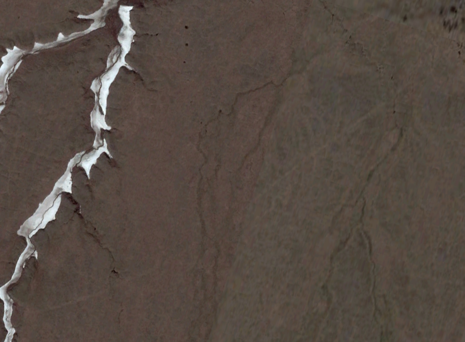
The faint scar you can see running diagonally from the bottom-left to upper-right was created by seismic work done in 1984-85 within the 1002 Area, using basically the same winter methods as are still used today. This scar may never disappear. Something like 5% of the ruts created back then are still visible from space, such as seen here in Google Earth near Camden Bay, but a comprehensive analysis using high resolution photography and topographic maps like the ones I created this summer has never been attempted, so likely we soon will be discovering the full impacts of that work from 30 years ago. From what we know so far, the deepest scars are caused by the mobile hotel for hundreds of workers being dragged around and getting stuck/unstuck. The density of the 1980’s seismic lines were several miles apart, with a total line length of about 1400 miles; compare that to the 200 meter spacing and 38,000 miles proposed for this winter…
So what’s the big deal if some tundra gets crushed? I conducted the only systematic topographic mapping analysis of these 3D seismic methods this summer, studying the impacts of seismic work completed adjacent to the 1002 Area this spring, and found the trails left behind in summer were 4 – 30 centimeters deep and 5 – 30 meters wide. I mapped them three times throughout the summer, and though my self-funded analyses are only in their preliminary stage I did see some rebounding occur, but the trails themselves remained clearly visible from the air and topographically until they were buried by snow this winter – a checkerboard of trails as far as the eye could see. The real point here is that while a 2 inch deep rut 38,000 miles long may seem insignificant to the BLM, it is not necessarily insignificant to the tundra.
Though there are many reasons this work should not be allowed to move forward using the methods proposed, here are a couple of my personal favorites:
- Regardless of the ecological damage, creating the visual scar of a 200 meter x 200 meter checkerboard across this entire region is simply unacceptable to me. This land is zoned to be protected from such harm, and the new law only allows 2000 acres of disturbance, far less than the 150,000 acres proposed here (61,000 km of trail times an average trail width of 10 m equals 150,000 acres). By analogy, just because four wheelers and dirt bikes are legal, doesn’t mean you should let your kids do donuts in the your neighbor’s beautiful front lawn. Most people consider this land, by law, to be their beautiful front lawn – regardless of the law, it’s simply in poor taste to treat your neighbor’s land with anything but respect.
- There is simply no way this amount of traffic is not going to cause unplanned mayhem. You can’t even drive a snowmachine in a straight line anywhere across the 100 mile width of the 1002 Area without getting it stuck at least once, if not multiple times. When one of these large vehicles gets stuck, it means the snow does not support enough traction, and the tundra below is the only thing that will support the traction needed for the even larger vehicles needed to extract the stuck vehicle. And driving so many large vehicles 24/7 through the coldest part of winter, is it really reasonable to think that hydraulic lines are not going to blow out, oil seals fail, and hydrocarbons of various kinds not left behind along this huge grid?
- There is simply not enough snow out here. Much of the lumpy ground gets scoured completely free of snow by the strong, persistent winds that blow here. Much of this snow sublimates and some of it forms drifts in the the gullies, but in either case it leaves much of the tundra exposed throughout winter.
- Even if the tundra mat is not broken anywhere by these enormous vehicles, the evolutionary trajectory of the plants in this region could be permanently altered, as this 38,000 mile checkerboard of extra soggy trail selectively gives advantage to some species over others, which might then find it easier to dominate the entire landscape through colonization, as once those species go to seed no part of the landscape will be ever more than 100 m away from such a soggy trail.
- Consider the speeds at which this work must take place: driving the entire 38,000 in 2 months working 24/7 means that vehicle has to be moving 4 mph all the time. While it may be that no single vehicle is driving the full course, the point is that there is tremendous time pressure to conduct an enormous amount of work in a short amount of time, and in such conditions short cuts will always be taken and mistakes will always be made.
- When you put a network of linear trails 4-30 cm deep across a series of wetlands perched only a few inches above one another, you have the potential to drain one into next in a series of cascading disasters. Flying over this terrain, you can see this has happened many times over the millenia due to more natural processes, so this terrain is sensitive to this behavior. But stimulating or revving up these dynamics with large vehicles operating over the entire 1.5 million acres in a single winter could lead to massive, irreversible changes, especially considering the increased sensitivity to disturbance caused by warming over the past 100 years.
- The most rugged terrain of the 1002 Area is utilized by polar bears to make dens to birth and raise their cubs. They purposely make these dens hard to find, and the best human efforts to find them for scientific purposes are only marginally successful. That is, trying to find and avoid all of these dens in the middle of winter is simply impossible, and given the close spacing of the proposed seismic lines it seems inevitable that some or many of these dens will be driven over and its occupants killed.
I know that many scientists have written letters to BLM to describe the harm that current seismic methods could cause here, though I’ve only seen a few. I’ll update this list as I learn more:
- Dr Matt Nolan, Physical impacts to the landscape: letter, related article
- Dr Skip Walker, Botanical impacts: letter, related article
- Dr Steve Armstrup, Polar bear impacts: letter, related article
But all is not doom and gloom in my mind – I do believe that we can do the necessary seismic work here without leaving any impact. But I don’t have all of the answers – this will take a team of dozens of the world’s leading experts on all of the scientific and engineering disciplines involved to work together constructively to develop a research plan that will identify and fill the gaps within our existing collective knowledge.
We already know there is a lot we don’t know, but here are a few of my favorites:
- We know almost nothing about snow cover in the 1002 or how much snow cover is really required to prevent any impacts to the tundra below. Any rational, thoughtful environmental scientist would agree that we need at least 3 years, if not 5 years, of snow cover data to get a handle on the statistics here – for example, are there areas that are never snow covered enough to support the current minimum snow cover requirements? From what I have seen over 15 years, the answer is yes, and no one has made more snow thickness measurements here than I have. And where do the current requirements come from and are they sufficient? No one really seems to know their origin, and the requirements seem to differ for various projects. We need a comprehensive study of the impacts of the past 10-20 years of 3D seismic using these minimums to determine their efficacy, as no such study has occurred or been attempted.
- We need to study the topography of the landscape to determine where the most sensitive areas are from a permafrost hydrology and permafrost ecology standpoint, so that we know where to take the most care or determine how to regulate methods used within these areas. Each watershed really is unique in terms of its tectonic origin and the ecology it currently supports, and this needs to be studied on the decimeter level.
- We need to understand the underlying geology better before permitting a 200 m x 200 m grid everywhere. We already have a good sense of where the oil is and isn’t and where the subsurface is deformed and where it isn’t. While it’s true we need more seismic everywhere in order to fully understand the geology here, we don’t need this density of seismic lines everywhere. A 200 m x 200 m is useful in those complicated areas where oil is likely to be found, as it will cause fewer dry wells to be drilled, but much of the area is either not that complicated or the oil is likely located below the complicated area, so let’s target our resources and isolate the potential for damage in those areas that are most complicated geologically, and reduce the density lines elsewhere.
- And because of the interplay between geology and ecology, among many other reasons, any seismic data collected here need to be shared publicly. The tax payers have made a huge investment into this process already and they are being asked to take an enormous risk of damaging a sensitive environment, so if any drilling is to occur out here then the owners of this land, the American people, deserve a full justification for it, including all of the facts when it comes to the economic analysis involved. Yes, the seismic work will be very expensive, especially if done right, but the companies involved stand to make billions from it and there is nothing within the law that says the data need to remain proprietary – if we the people want to make data sharing a condition for exploration, it is totally within our rights to do so, and if that scares off some of the players from getting involved, that’s simply the price of playing poker out here. And such a data-sharing requirement does not require an act of Congress, it simply needs to be written into the permit conditions. But this will not occur unless the owners of this land demand it.
In the end what frightens me most about the potential for permanent impacts out here is the question: if industry and its government supporters are truly interested in acting responsibly, why have they not been conducting such studies here already? Or anywhere for the matter. None of these studies are expensive in comparison to the seismic or drilling, all of them and many more are possible, there are tons of experts in academia right here in Fairbanks who have the requisite skills — so why not? And now that drilling is approved, why skip this stage? This stage called ‘think before you act’?
While I believe such a gathering of experts will develop many new ideas to improve existing methods, including perhaps many better than what I propose here, to me right now the solution is simple and I throw it out as the baseline challenge that is guaranteed to solve the checkerboard problem — the checkerboard is caused by driving or dragging hundreds of tons of people and gear, so the simplest way to eliminate the checkerboard is to eliminate the driving:
- To eliminate most of the driving, all you need to do is eliminate the mobile four star hotel, which probably accounts for 80% of the weight being moved and seems to cause the worst damage. Put out the word, and I’d bet you would get thousands of qualified applicants to fill the several hundred positions needed that would be willing to eliminate the mobile hotel by sleeping in tents, commuting by ski, and eating dehi meals to prevent the possibility of this checkerboard.
- To eliminate much of the rest of the driving, eliminate wires between the seismic receivers. Autonomous wireless geophones powered with batteries that could last weeks or months (or even years with solar) could be deployed and retrieved by helicopter or people on skis rather than someone stepping out of their mobile hotel room that leaves a wake of crushed tundra behind it.
- To eliminate the remaining driving, change the seismic source methods. While using truck-mounted vibroseis sources are convenient and arguably the best method here from a scientific and cost standpoint, explosives were used here in the 1984-85 work and found sufficient for the job. More importantly, they can be deployed without driving by using helicopters to sling drill rigs.
- Wherever you eliminate the need for driving to move the people, the sources, and the receivers, you eliminate the restriction for winter-only work. This means we can wait for the polar bears to leave their dens before doing the work in their area. This means we can wait for the caribou to leave an area before doing the work near them. This means we have a whole ‘nother 9 months to do the work per year, and do it in daylight when you can see what the heck is going on. One of the impacts of climate change is that winters here are getting shorter and the window for doing this work is getting shorter over time, now only 2-3 months, so more time and daylight can only serve to help reduce mistakes and ill-considered short cuts.
- While there is still potential for damage with such methods, the potential impact is thousands of times less because most of the potential for damage is caused by the land vehicles, so any reduction in driving reduces damage potential, so eliminating the driving eliminates that potential completely. Plus point source damage, such as from the explosives or wireless geophones, is actually mitigatable, unlike driving damage, and point sources are nearly impossible to see compared to linear tire tracks, especially if the locations for these are chosen with the most easily mitigatable terrain in mind.
The origin of our planet and the dynamics of its molten core covered by a solid geochemical scum have conspired to create one of the most beautiful and rich landscapes in the world, one that supports a unique and special ecology that ranges from the charismatic megafauna like polar bears and caribou to migratory bird species from around the world to mosquitos by the billions and that has, until quite recently, been protected from widespread, man-made catastrophe. Indeed, especially when combined with the adjacent Canadian parks, the 1002 Area may be the largest, best protected tundra ecosystem on the planet. This alone, this protection, is a reason to celebrate 10/02 Day. An enormous amount of effort and collective political will and compromise from one of the strangest and most diverse political alliances in American history was required to put this protection into place. In many ways, though not without its own controversy and acrimony, the alliance that created these protections could be a role model for what we could aspire to again on so many issues, to help us remember how we can come together to do something great when we put our minds to it. While it is certainly true that petroleum exploration and extraction were written into the law as a possibility here (within Section 1002 of ANILCA), such that at any time the majority agree that exploration here is a good idea then the law will allow it. The flip side is, however, that any time the majority agree that exploration here is bad idea then the law will prohibit it. And in the current political environment, the pendulum does not have to swing far, as the majority of American citizen oppose any petroleum-related activities out here (I have yet to find a poll that has my category in it — supporting publicly-shared impact-free seismic data…). I’ve said this before but I think it’s worth repeating – if the first thing that happens out here is the creation of a 38,000 mile long checkerboard of trails with its 150,000 acres of disturbance, everyone will lose: those seeking to extract oil won’t be able to and those seeking to show their children a phenomenal monument to human-planetary goodwill wont be able to either. We can do better.
I have the impression that the current powers-that-be are ramrodding this seismic work through the system without the required responsible analyses and methods because they fear the law will be changed back if they wait that long. If that’s true, to me it seems they are shooting themselves in the foot by doing this – if those in charge took a deep breath, slowed down, and acted responsibly by performing the needed studies, improving current methods, and implemented a plan that would truly cause no impacts, they would likely gain the support needed to keep this law from being changed back. And then everyone could win: we would all gain a better understanding of this unique and complicated geology without leaving any trace behind as to how we did it. How those data are used afterwards is a completely different and unrelated question in my mind — those who claim to support the scientific method in their pursuit of truth should know that the quest for the truth should not consider the downstream ramifications of knowing the truth, else they are not following the scientific method rightly understood.
So on this 10/02 Day, I hope you will celebrate the beauty and uniqueness of the 1002 Area by taking the time to learn more about it and perhaps letting those in charge (such as the BLM or your elected politicians) know that you agree that acting responsibly, being good neighbors, and protecting this area are important to you. There are many excellent resources to learn more about the 1002 Area and the Arctic National Wildlife Refuge and I encourage you to read them — here are three of my personal favorites which I think capture the political history, the geologic setting, and the physical beauty as starting points for further exploration. And of course, there is no substitute for a visit…