Fairbanks Fodar

Fairbanks Fodar’s mission is to take advantage of the current renaissance in photogrammetry by putting the power of affordable, frequently-acquired DEMs to work for you.

Read more

Understanding Fodar

Fodar is an airborne photogrammetric technique that produces directly georeferenced DEMs and orthoimages with the accuracy and precision of lidar but at a fraction of the cost.

Read more

Applications

Fodar has many applications. If you are unfamiliar with DEMs, orthophotos, difference images, and fodar, you may want to see this fodar tutorial first.

Read more

Fodar Earth

If you like Google Earth, you’ll love Fodar Earth — more features, better data and all Fodar.  We can share 100s of gigabytes of data with the world or just your colleagues within days of acquisition.

Read More

Featured Projects

In winter and summer of 2021, we mapped about 3000 km2 of northwestern Alaska within the NPRA, including CWAT trail, making about 50 billion measurements of snow depth at 25 cm posting by subtracting the summer map from the winter one. This is likely the more comprehensive and accurate map of snow depth in the Arctic ever made. Click here to learn more.


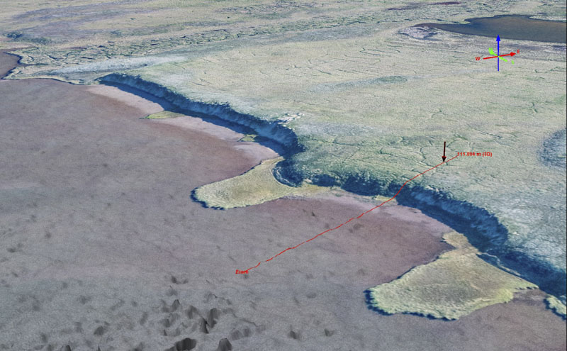
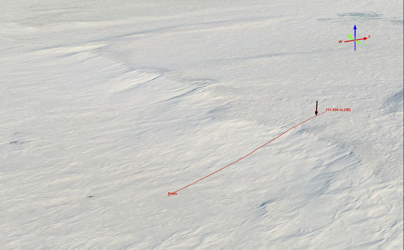
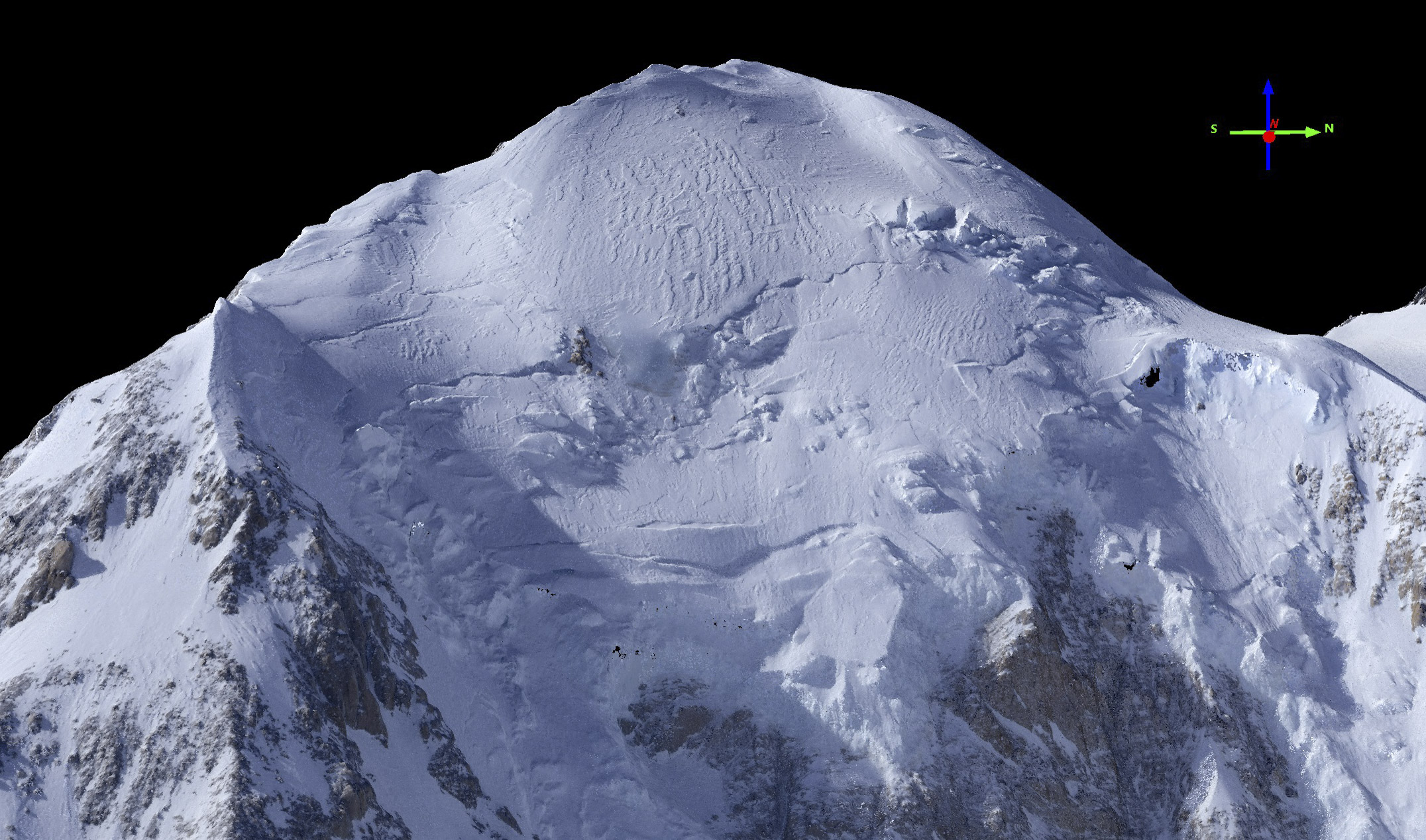
In April 2018, we mapped Denali, the tallest mountain in North America.
Our map has a resolution and accuracy
that is hundreds of times better than the next best map.
Read more about the project here.

ff_2016_flights
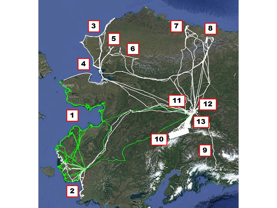
In 2015-2016, Fairbanks Fodar flew over 450 hours of mission flying throughout the State.
Click here to learn more about our recent projects.

Testimonials

  • We were extremely satisfied with the rapid collection and delivery timelines (<1 week from funding).  The delivered products were ready for immediate use and are fully meeting our needs for a rapid, high-quality DEM and ortho product  in support of geohazard assessments in coastal Alaskan villages.

    Anonymous State Employee
    Anonymous State Employee (Name withheld to eliminate endorsement conflicts)
  • Dr. Nolan acquired and delivered a DEM and ortho to us of a large area of the North Slope within two weeks of funding. The data were delivered exactly as specified. The combination of cost and quality have allowed us to study denning habitats with unprecedented detail.

    Anonymous AK State Employee
    Anonymous AK State Employee (Government employee names are withheld to eliminate endorsement conflicts)
  • Dr. Nolan's Fodar maps have allowed us to detect and measure permafrost melt over huge areas for a fraction of the cost and effort of measuring just a few features on the ground.

    Anonymous Federal Employee
    Anonymous Federal Employee (Government employee names are withheld to prevent endorsement conflicts)
  • Fairbanks Fodar was able to synchronize their acquisitions with our field work on the Arctic Ocean coast and the airborne data were processed by the time we returned from the field!

    Anonymous Federal Employee
    Anonymous Federal Employee (Government employee names are withheld to prevent endorsement conflicts)
  • Dr. Nolan's SfM measurements of snow depth at my field sites really worked and have tremendous potential for snow science.

    Dr. Matthew Sturm
    Dr. Matthew Sturm Snow Scientist, Professor, UAF
  • We found Dr. Nolan's fodar measurements so accurate and cost-effective that we decided to lease a system from to operate on our own so that we could use it all the time.

    Anonymous Federal Employee
    Anonymous Federal Employee (Government employee names are withheld to prevent endorsement conflicts)
  • Fodar allowed us to finally resolve which is the tallest peak in Arctic Alaska, with Fodar matching our DGPS to within centimeters. Dr. Nolan was a pleasure to work with and the whole process was far more affordable than I imagined.

    Kit Deslauriers
    Kit Deslauriers Ski Mountaineer and The North Face Ambassador
  • I'm a field scientist.  Did you just put me out of a job?

    Anonymous Federal Employee
    Anonymous Federal Employee (Government employee names are withheld to prevent endorsement conflicts)

Fodar News

Special Offers

(please enquire about additional terms and conditions)
Grad Student Stimulus
We will map your Alaskan field area for whatever you can afford
Grad students, like Fodar, are the future of earth sciences, so we want to help pair the two up early. The catch is that is has to be used in an already-funded project, you have to accept that the acquisition will occur when convenient to us, and project size is limited to about 1 gigapixel (for example, 10 km x 5 km @ 25 cm GSD is 0.8 gigapixels).
Federal Pilot Project
You can buy a map of your Alaskan field area from our archive for $2999
Federal scientists face many challenges, so we’d like to make at least one things easier for them. Let us know about areas you would like to try out Fodar that are about 1 gigapixel in size (for example, 10 km x 5 km @ 25 cm GSD is 0.8 gigapixels) and we will sell it to you from our archive.
Lidar Smackdown
Bring us your valid lidar quote, and we will beat it by a factor of 10.
Bring us your valid lidar quote and Fairbanks Fodar will beat it by a factor of ten, just because we can. This means that we will quote the same specs at 10x less cost, or 2x better specs at 5x less cost, etc, at our discretion.
Alaska Grand Challenge
Fairbanks Fodar will map the entire state of Alaska for $5M
Alaska’s topography is changing in ways that most multi-meter DEMs wont detect for decades. Fodar would allow us to detect nearly all changes, as they are occurring. Here the entire state means the mainland, minus the Aleutians and panhandle, with the bulk of it at an average resolution of 25 cm GSD.
Nature Paper Reward
Publish a paper in Nature or Science that uses Fodar data, and we will map that same area again for half the price
Publishing scientific results based on Fodar data helps spread the word about Fodar and we want to reward those that do so. If you paid regular rates for your first acquisition, we’ll acquire the same area again for half the price (or possibly a new area at half price if you have another promising idea).
NSF/OPP Proposal Proposition
Propose two Fodar acquisitions for change detection in Alaska in your upcoming NSF/OPP proposal, and we will make a 3rd acquisition for free.
If you can afford to collect elevation data in the field from transects and point measurements, you can probably afford Fodar and eliminate the need for extrapolations completely. We want to encourage you to demonstrate this for yourself by adding one more acquisition to your time-series.
Fairbanks Local’s Coupon
Three maps of any business or residential property in Fairbanks for $1000.
Whether you are a realtor looking to sell property, a lawyer investigating crime scenes, a general contractor tracking progress of a big construction project, or just a home owner looking for photos to hang on the wall, Fairbanks Fodar is happy to provide you with data. Catches apply, please enquire.
Emergency Relief Pledge
If human life is at risk, Fairbanks Fodar will assist any government relief efforts with just a phone call.
Whether it’s a flood on the Yukon, a storm surge on the coast, or a plane crash in the bush, Fairbanks Fodar can make high-resolution orthoimages and DEMs that can be served online same-day to support relief efforts and is happy to do it if we can.
Contact Us

We're not around right now. But you can send us an email and we'll get back to you, asap.

Not readable? Change text. captcha txt