
A Happy Day in Hooper Bay
This morning the best weather on the west coast was in the place where the weather is usually the worst, so I headed there.
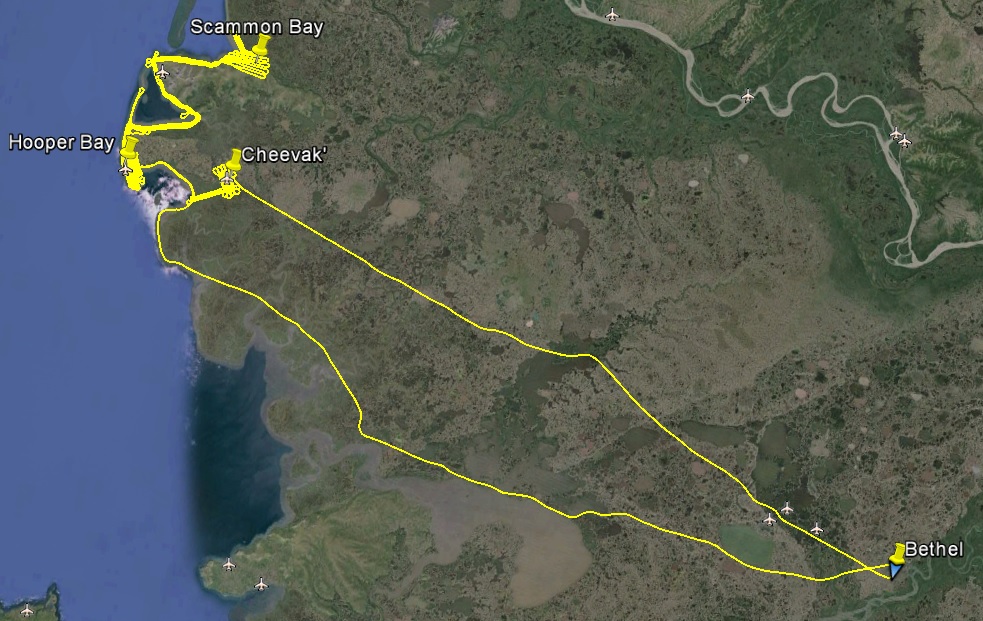
Between the Yukon and Kuskokwim River deltas lies some small mountains surrounded by tundra that form Hooper Bay and Scammon Bay. Other than an outcrop near Toksook Bay, this is the largest terrain between Unalakleet and Bethel, and looks enormous compared the flatness that characterizes the area. It also juts out into the Bering Sea, just waiting to pick up and trap moisture from any direction as well as whip any air moving past into a froth. Today, however, it was calling clear calm skies to 10,000′ while most everywhere else was 2000′ or less. Indeed, Bethel in the morning was IFR. It is also about the furthest spot from any of my bases with fuel, namely Unalakleet or Bethel, and when planning the overall mission I knew that this location would be the problem child of the trip, so I was excited to take advantage of what seemed like a good opportunity.
I hung out at the airport for a few hours in the morning, chatting with the friendly pilots at Renfro’s. They largely just shake their head and smile when I talk about needing 2700′ over the whole coast, but today they emphasized the point by telling me about the special special VFR procedures at the Bethel airport. Yes, that’s a double special. A special VRF clearance allows you to fly into an airport which is currently in IFR conditions. There so much IFR here though that they have a special rule about special VFR clearances that has its own procedure routes with holding locations like a true IFR clearance, except that you can get it straight from tower on your way in. What this leads to is a bunch of planes circling below the clouds at 400′ just outside the airport boundary waiting for breaks in the true IFR traffic, then everyone makes a mad dash for the runway. I’m still having trouble landing on the right runway and taxiing on the right taxiways when I can see where I’m going, I can hardly guess how much gray hair I would cause the controllers with a special special.
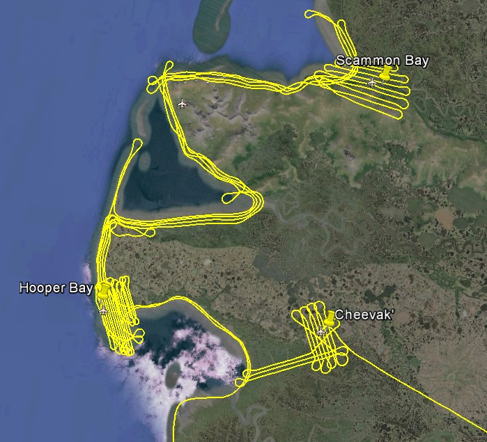
In any case, I waited until the clouds lifted enough that I didnt have to ask for a special special (locally known as a Sierra departure), and took off to the west. The ceiling never rose above 1000′ and was often less for the first 100 miles, but closer to coast I could see it brightening in my direction. As I got close in, I could see what the cameras and awos were looking at, and it was beautiful. Unfortunately surrounding each station were low clouds, making me wonder if the local tourism boards are the ones aiming those cameras. The clouds were low, but fortunately not too low, or at least not all at once. I had to work where the ceilings were high and hope the other areas opened up in the meantime, which more or less they did, though I did a fair amount of backtracking. It was a process that tested all of my flying, weather, mapping, and photographic skills, trying to keep straight where this or that cloud was 20 minutes ago and fill in that gap, or when the cloud wouldnt move I had to fly lower and keep track in my head how much narrower my swath width was and how much closer the next line had to be to accommodate that, or adjust the exposures for this thick overcast or this bit of bright sun, all the while keeping track of the other traffic in the area. It makes me chuckle when I hear people thinking they can do a job like this with a UAV. It especially makes me chuckle because while in Unalakleet I watched the Battle of Britain on VHS (apparently Maggie scored an entire video store’s worth of VHS at some point), and towards the end of the movie one of the main guys is being asked for his interpretation of the latest news and he says something like “Well, either we have just won the war or just lost it, and we will find out in a few days. What we say about it in the meantime really doesnt matter because there is nothing we can do about it.” I kind of feel that way about UAVs, let them talk big, time will tell whether they can succeed at something like this and what anyone says either way in the meantime is a waste of breath. I’m sure there’s plenty of people that dont think I can pull this off even in a manned aircraft, and until I do there’s no point in debating that either.
In the end I mapped the villages of Hooper Bay, Scammon Bay, and Cheevak, plus most of the coast in between them, taking some 6100 photos over a ten hour trip. The significance of this to me is that I now have essentially defined a midpoint to work towards from the north and south, with the longest distance, worst weather, most crenulated site out of the way. So it wasnt a lot of area in total, but it was something that needed to get done and was a motivational milestone to succeed at the worst location if nothing else. Today was also the first day I got to fly home without mapping, which made for an enjoyable end to a successful day to just fly low and slow and check out the scenery directly rather than by using a mouse…
I never thought I’d have a job with an hour and half commute each way. But as commutes go, it was a pretty enjoyable one.
About seven hours of stunt flying. I was out there so long that several planes came and went two times and I was asked more than once how much fuel I was carrying…